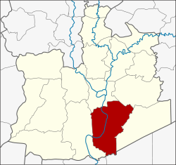
Bang Pa-in (Thai: บางปะอิน, pronounced [bāːŋ pā.ʔīn]) is one of the 16 districts (amphoe) of Phra Nakhon Si Ayutthaya province, central Thailand.
Bang Pa-in
บางปะอิน | |
|---|---|
 | |
 District location in Phra Nakhon Si Ayutthaya province | |
| Coordinates: 14°13′39″N 100°34′32″E / 14.22750°N 100.57556°E | |
| Country | Thailand |
| Province | Ayutthaya |
| Tambon | 18 |
| Muban | 149 |
| Seat | Ban Len |
| Area | |
• Total | 229.098 km2 (88.455 sq mi) |
| Population (2000) | |
• Total | 73,630 |
| • Density | 320/km2 (830/sq mi) |
| Time zone | UTC+7 (ICT) |
| Postal code | 13160 |
| Geocode | 1406 |
History
editBang Pa-in was established in the Ayutthaya era in the name Khwaeng Uthai. In the Rattanakosin era Khwaeng Uthai was divided to be Khwaeng Uthai Noi and Uthai Yai. In 1910 Khwaeng Uthai Noi was changed status and renamed to Phra Ratchawang District. The district name was changed again to Bang Pa-in after the name of Bang Pa-in island in 1915.
Its name Bang Pa-in is believed to be distorted from Bang Phra In (บางพระอินทร์), literally meaning "place of Indra", refers to place of Inthraracha, the title of Songtham before became the king. It is believed that he was the son of Ekathotsarot and local woman named In (อิน) or O In (อออิน). [1]
Bang Pa-in in Ayutthaya era was once called Bang Kradan (บางกระดาน) or Bang Khadan (บางขดาน), which means "place of plain", since it was a spacious plain and a part of Thung Luang Field, a vast field of central region and Chao Phraya basin. It was also used as a place for royal water repellent ceremony during the flood season.[2]
The historic building Bang Pa-in Royal Palace was built during the Prasat Thong's reign, which was believed that he was a cousin to Songtham.[2]
Geography
editNeighboring districts are (from the north clockwise) Phra Nakhon Si Ayutthaya, Uthai and Wang Noi of Ayutthaya province, Khlong Luang of Pathum Thani province, and Bang Sai of Ayutthaya.
Administration
editThe district is divided into 18 sub-districts (tambon), which are further subdivided into 149 villages (muban). There are nine municipal (thesaban) areas, and nine tambon administrative organizations (TAO).
| No. | Name | Thai | Villages |
|---|---|---|---|
| 1. | Ban Len | บ้านเลน | 12 |
| 2. | Chiang Rak Noi | เชียงรากน้อย | 12 |
| 3. | Ban Pho | บ้านโพ | 9 |
| 4. | Ban Krot | บ้านกรด | 11 |
| 5. | Bang Krasan | บางกระสั้น | 17 |
| 6. | Khlong Chik | คลองจิก | 8 |
| 7. | Ban Wa | บ้านหว้า | 7 |
| 8. | Wat Yom | วัดยม | 8 |
| 9. | Bang Pradaeng | บางประแดง | 9 |
| 10. | Sam Ruean | สามเรือน | 8 |
| 11. | Ko Koet | เกาะเกิด | 7 |
| 12. | Ban Phlap | บ้านพลับ | 5 |
| 13. | Ban Paeng | บ้านแป้ง | 4 |
| 14. | Khung Lan | คุ้งลาน | 5 |
| 15. | Taling Chan | ตลิ่งชัน | 6 |
| 16. | Ban Sang | บ้านสร้าง | 8 |
| 17. | Talat Kriap | ตลาดเกรียบ | 8 |
| 18. | Khanon Luang | ขนอนหลวง | 5 |
See also
editReferences
edit- ^ Bunnag, Rome (2016-01-15). ""บางปะอิน" อนุสรณ์รักพระเอกาทศรถ ทรงว่ายน้ำขึ้นเกาะ พบอออินสาวชาวบ้าน!!!" ["Bang Pa-in" love memorial of King Ekathotsarot when he swam up to the island and meet O-in a local woman!!!]. ASTV Manager (in Thai). Retrieved 2019-12-06.
- ^ a b "สุวรรณภูมิในอาเซียน : เรือพระราชพิธี กรุงศรีอยุธยา ล่องไปทำพิธีกรรมบางปะอิน" [Suwannaphum in ASEAN : Ayutthaya royal barge go to Bang Pa-in ritual]. Matichon (in Thai). 2019-12-05. Retrieved 2019-12-06.
External links
edit- Bang Pa-In travel guide from Wikivoyage