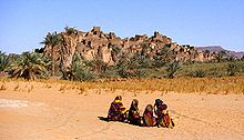
The Djado Plateau lies in the Sahara, in northeastern Niger. It is known for its cave art (often of large mammals long since absent from the area), but is now largely uninhabited, with abandoned towns and forts still standing and visible. As of 2012, the commune of Djado had a total population of 876 people.[1]

World Heritage Status
editThis site was added to the UNESCO World Heritage Tentative List on May 26, 2006, in the Cultural category due to its universal cultural significance.
Djado City
editThe ruined city and ksar of Djado lies on the southern end of the plateau at 450 metres (1,500 ft) of elevation within a small oasis of brackish water. It was long ago abandoned by the Kanuri people, who may have been the original founders. Before the abandonment of Djado city, the area was well known for its salt and date production. Now, the salt mines in Djado are rarely used, however there are date palms of the area that are tended by Toubou nomads [2][3]
See also
editReferences
edit- ^ "Djado (Commune, Niger) - Population Statistics, Charts, Map and Location". www.citypopulation.de. Retrieved 2024-02-16.
- ^ S., Vikør, Knut (1999). The oasis of salt : the history of Kawar, a Saharan centre of salt production. Centre for Middle Eastern and Islamic Studies. ISBN 1-85065-308-9. OCLC 1101266162.
{{cite book}}: CS1 maint: multiple names: authors list (link) - ^ "Old Djado Ruins of Niger". Retrieved 27 June 2017.[permanent dead link]
External links
edit20°58′59″N 12°19′59″E / 20.983°N 12.333°E