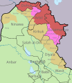
Size of this PNG preview of this SVG file: 520 × 600 pixels. Other resolutions: 208 × 240 pixels | 416 × 480 pixels | 666 × 768 pixels | 887 × 1,024 pixels | 1,775 × 2,048 pixels | 650 × 750 pixels.
Original file (SVG file, nominally 650 × 750 pixels, file size: 455 KB)
File history
Click on a date/time to view the file as it appeared at that time.
| Date/Time | Thumbnail | Dimensions | User | Comment | |
|---|---|---|---|---|---|
| current | 20:19, 16 November 2024 |  | 650 × 750 (455 KB) | Zemen | File uploaded using svgtranslate tool (https://svgtranslate.toolforge.org/). Added translation for ckb. |
| 13:16, 8 November 2017 |  | 650 × 750 (432 KB) | Rob984 | Reverted to version as of 14:38, 7 November 2011 (UTC) This map illutrates the siutation before Halabja became a province. Also those boundaries for Halabja are wrong. | |
| 16:09, 27 June 2014 |  | 650 × 750 (434 KB) | Nightstallion | Reverted to version as of 02:59, 13 June 2014, Halabja | |
| 11:14, 25 June 2014 |  | 650 × 750 (432 KB) | Kathovo | Reverted to version as of 10:47, 25 June 2014, You have changed the scope with this edit, please refer to COM:UPLOADWAR | |
| 11:04, 25 June 2014 |  | 650 × 750 (434 KB) | Spesh531 | Reverted to version as of 23:47, 20 June 2014 Disputed areas are still being shown according to Article 140, the administrator has changed sides, however. it would not follow article 140 of the red | |
| 10:47, 25 June 2014 |  | 650 × 750 (432 KB) | Kathovo | Reverted to version as of 14:38, 7 November 2011 map is meant to show areas designated by the Article 140 of the Iraqi Constitution | |
| 23:47, 20 June 2014 |  | 650 × 750 (434 KB) | Spesh531 | no info on baaj | |
| 19:47, 17 June 2014 |  | 650 × 750 (438 KB) | Spesh531 | areas are controlled by Kurdistan are now pink | |
| 15:41, 13 June 2014 |  | 650 × 750 (448 KB) | Haghal Jagul | After the ISIS invasion and its detailed developments | |
| 02:59, 13 June 2014 |  | 650 × 750 (434 KB) | Spesh531 | with Halabja |
File usage
The following 4 pages use this file:
Global file usage
The following other wikis use this file:
- Usage on ar.wikipedia.org
- Usage on ast.wikipedia.org
- Usage on azb.wikipedia.org
- Usage on az.wikipedia.org
- Usage on be-tarask.wikipedia.org
- Usage on be.wikipedia.org
- Usage on ckb.wikipedia.org
- Usage on es.wikipedia.org
- Usage on fa.wikipedia.org
- Usage on fi.wikipedia.org
- Usage on he.wikipedia.org
- Usage on sv.wikipedia.org
