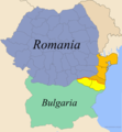
Dobrogea-cadrilater.png (337 × 364 pixels, file size: 12 KB, MIME type: image/png)
File history
Click on a date/time to view the file as it appeared at that time.
| Date/Time | Thumbnail | Dimensions | User | Comment | |
|---|---|---|---|---|---|
| current | 07:41, 9 August 2016 |  | 337 × 364 (12 KB) | Jack-ONeill55 | removed yellow spot in the north-east (Ukraine) |
| 18:32, 2 March 2014 |  | 337 × 364 (29 KB) | Jakeukalane | Border with the sea. | |
| 19:07, 17 February 2014 |  | 337 × 364 (13 KB) | Spiridon Ion Cepleanu | Cosmetic little change | |
| 12:11, 5 May 2008 |  | 337 × 364 (15 KB) | Olahus | ||
| 17:13, 5 February 2006 |  | 337 × 364 (14 KB) | Anonimu~commonswiki | Reverted to earlier revision | |
| 23:56, 10 December 2005 |  | 337 × 364 (14 KB) | 5ko | The map with the Mangalia Strip in dark orange. Uploaded to en:Image:Dobrogea-cadrilater.png by en:User:Constantzeanu Dec. 7, 2005. | |
| 17:54, 18 April 2005 |  | 337 × 364 (14 KB) | Bogdan | Map of Romania and Bulgaria with Dobruja highlighted Source: Made by me {{GFDL}} Category:Maps of RomaniaCategory:Maps of Bulgaria\ |
File usage
The following 5 pages use this file:
Global file usage
The following other wikis use this file:
- Usage on be-tarask.wikipedia.org
- Usage on be.wikipedia.org
- Usage on ca.wikipedia.org
- Usage on cs.wikipedia.org
- Usage on da.wikipedia.org
- Usage on de.wikipedia.org
- Usage on el.wikipedia.org
- Usage on eo.wikipedia.org
- Usage on es.wikipedia.org
- Usage on et.wikipedia.org
- Usage on fa.wikipedia.org
- Usage on fi.wikipedia.org
- Usage on fr.wikipedia.org
- Usage on gl.wikipedia.org
- Usage on he.wikipedia.org
- Usage on hr.wikipedia.org
- Usage on id.wikipedia.org
- Usage on it.wikipedia.org
- Usage on ja.wikipedia.org
- Usage on ko.wikipedia.org
- Usage on lt.wikipedia.org
- Usage on nl.wikipedia.org
- Usage on nn.wikipedia.org
- Usage on no.wikipedia.org
- Usage on oc.wikipedia.org
- Usage on pl.wikipedia.org
- Usage on pt.wikipedia.org
- Usage on ro.wikipedia.org
View more global usage of this file.

