
No higher resolution available.
France_departements_regions_narrow.jpg (520 × 550 pixels, file size: 68 KB, MIME type: image/jpeg)
| This is a file from the Wikimedia Commons. Information from its description page there is shown below. Commons is a freely licensed media file repository. You can help. |
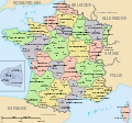
| Description | Map of official départements and régions of France, with French titles (in JPEG format for larger, rapid display: 5x faster than SVG). French: Départements et régions, en Francais. | ||
| Date | |||
| Source | Image:Départements+régions (France).svg (Wikimedia file, converted to quick JPEG and narrowed 15%) | ||
| Author | self (after User:Historicair 6-Nov-2006) | ||
| Permission (Reusing this file) |
|
||
| Other versions | Wider view, large 254kb SVG file: Image:Départements+régions (France).svg |

|
File:Départements+régions (France).svg is a vector version of this file. It should be used in place of this JPG file.
File:France departements regions narrow.jpg → File:Départements+régions (France).svg
For more information, see Help:SVG. |
.svg) |
Variations
-
 CURRENT IMAGE: Départements 520px (15% magnified, rapid JPEG format)
 -
 Départements 588px (régions en lettres et colorisé, wider view, same labels, SVG format 5x slower)
 -
 Départements sans colorisé (numeric labels, uncolorized)
 -
 Départements de France avec un découpage régional


File history
Click on a date/time to view the file as it appeared at that time.
| Date/Time | Thumbnail | Dimensions | User | Comment | |
|---|---|---|---|---|---|
| current | 13:44, 21 March 2007 | | 520 × 550 (68 KB) | Wikid77 | Circled Paris in maroon red color, to tie inset to Paris region. |
| 12:02, 21 March 2007 |  | 520 × 550 (68 KB) | Wikid77 | {{Information |Description=Map of official départements and régions of France, with French titles (in JPEG format for larger, rapid display: 5x faster than SVG). ''French:'' Départements et régions, en Francais. |Source=[[:Image:Départements+région |
File usage
The following 3 pages use this file:
Global file usage
The following other wikis use this file:
- Usage on azb.wikipedia.org
- Usage on be.wikipedia.org
- Usage on ca.wikipedia.org
- Usage on cs.wikipedia.org
- Usage on fa.wikipedia.org
- Usage on fr.wikipedia.org
- Usage on hu.wikipedia.org
- Usage on hy.wikipedia.org
- Usage on id.wikipedia.org
- Usage on ja.wikipedia.org
- Usage on jv.wikipedia.org
- Usage on ka.wikipedia.org
- Usage on km.wikipedia.org
- Usage on my.wikipedia.org
- Usage on mzn.wikipedia.org
- Usage on nn.wikipedia.org
- Usage on sk.wikipedia.org
- Usage on sl.wikipedia.org
- Usage on sr.wikipedia.org
- Usage on sv.wikipedia.org
- Usage on te.wikipedia.org
- Usage on tl.wikipedia.org
- Usage on tr.wiktionary.org
- Usage on tt.wikipedia.org
- Usage on uk.wikipedia.org
- Usage on war.wikipedia.org
View more global usage of this file.