Size of this preview: 700 × 600 pixels. Other resolutions: 280 × 240 pixels | 561 × 480 pixels | 897 × 768 pixels | 1,196 × 1,024 pixels | 2,013 × 1,724 pixels.
Original file (2,013 × 1,724 pixels, file size: 263 KB, MIME type: image/png)
File history
Click on a date/time to view the file as it appeared at that time.
| Date/Time | Thumbnail | Dimensions | User | Comment | |
|---|---|---|---|---|---|
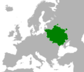
| current | 19:48, 31 January 2024 |  | 2,013 × 1,724 (263 KB) | HetmanTheResearcher | Added sourced version. An orthographic projection of this map: https://commons.wikimedia.org/wiki/File:Lithuania_Territorial_Extension_1430.svg |
| 22:16, 30 January 2024 |  | 2,000 × 1,529 (475 KB) | Marcelus | Reverted to version as of 15:26, 12 November 2018 (UTC); bad resolution, unsourced "claims", usually we don't show claims on such maps | |
| 17:22, 31 January 2023 |  | 800 × 811 (159 KB) | SeriousThinker | Updated version | |
| 15:26, 12 November 2018 |  | 2,000 × 1,529 (475 KB) | Sbaio | Reverted to version as of 15:37, 23 May 2016 (UTC) Restore prior version. The color of Coat of Arms does dictate the colors in the map | |
| 17:27, 28 September 2018 |  | 2,000 × 1,529 (391 KB) | Radom1967 | GDL coat of arms was red color. So adjusted map to red | |
| 15:37, 23 May 2016 |  | 2,000 × 1,529 (475 KB) | Vaidas V | User created page with UploadWizard |
File usage
The following page uses this file:
Global file usage
The following other wikis use this file:
- Usage on ar.wikipedia.org
- Usage on arz.wikipedia.org
- Usage on ast.wikipedia.org
- Usage on azb.wikipedia.org
- Usage on be.wikipedia.org
- Usage on bg.wikipedia.org
- Usage on bs.wikipedia.org
- Usage on ce.wikipedia.org
- Usage on cs.wikipedia.org
- Usage on cv.wikipedia.org
- Usage on cy.wikipedia.org
- Usage on de.wikipedia.org
- Usage on en.wiktionary.org
- Usage on eu.wikipedia.org
- Usage on fi.wikipedia.org
- Usage on fr.wikipedia.org
- Usage on gl.wikipedia.org
- Usage on he.wikipedia.org
- Usage on id.wikipedia.org
- Usage on it.wikipedia.org
- Usage on ka.wikipedia.org
- Usage on ko.wikipedia.org
- Usage on ltg.wikipedia.org
- Usage on lt.wikipedia.org
- Usage on lt.wikibooks.org
- Usage on lv.wikipedia.org
- Usage on mk.wikipedia.org
- Usage on ms.wikipedia.org
- Usage on oc.wikipedia.org
- Usage on pl.wikipedia.org
- Usage on pt.wikipedia.org
- Usage on ru.wikipedia.org
- Usage on sco.wikipedia.org
- Usage on simple.wikipedia.org
- Usage on sl.wikipedia.org
- Usage on sq.wikipedia.org
- Usage on sr.wikipedia.org
- Usage on th.wikipedia.org
- Usage on tr.wikipedia.org
- Usage on uk.wikipedia.org
- Usage on uz.wikipedia.org
- Usage on vi.wikipedia.org
- Usage on www.wikidata.org