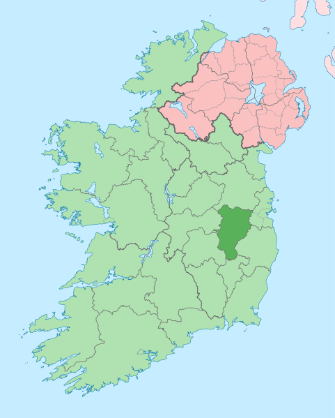
Size of this PNG preview of this SVG file: 481 × 599 pixels. Other resolutions: 192 × 240 pixels | 385 × 480 pixels | 616 × 768 pixels | 822 × 1,024 pixels | 1,643 × 2,048 pixels | 1,450 × 1,807 pixels.
Original file (SVG file, nominally 1,450 × 1,807 pixels, file size: 642 KB)
File history
Click on a date/time to view the file as it appeared at that time.
| Date/Time | Thumbnail | Dimensions | User | Comment | |
|---|---|---|---|---|---|
| current | 09:12, 3 July 2020 |  | 1,450 × 1,807 (642 KB) | Chipmunkdavis | Per the Local Government Reform Act 2014, joining both Tipperarys and both Waterfords (and removing Limerick City code). Colouring in islands, cleaning up and grouping code to remove stray objects and show Galway and Lough Ree. |
| 00:48, 19 July 2010 |  | 1,450 × 1,807 (815 KB) | Mabuska | {{Information |Description={{en|The island of Ireland, showing international border between Northern Ireland and Republic of Ireland, traditional provinces, traditional counties, and local authority areas in the Republic of Ireland and Northern Ireland.}} |
File usage
The following 90 pages use this file:
- Allen, County Kildare
- Allenwood, County Kildare
- Ardagh (barony)
- Ardclough
- Athy
- Ballitore
- Ballymore Eustace
- Ballyoulster
- Bog of Allen
- Brownstown, County Kildare
- Calverstown
- Caragh
- Carbury, County Kildare
- Carbury (County Kildare barony)
- Castledermot
- Celbridge
- Clane
- Clane (barony)
- Coill Dubh
- Connell (barony)
- County Kildare
- Cupidstown Hill
- Cutbush
- Derrinturn
- Eadestown
- Finnery River
- Grand Canal (Ireland)
- Grangemore
- Hawkfield
- Hempstown
- Hill of Allen
- Ikeathy and Oughterany
- Johnstown, County Kildare
- Kilberry, County Kildare
- Kilcock
- Kilcullen
- Kilcullen (barony)
- Kildangan
- Kildare
- Kilkea and Moone
- Kill, County Kildare
- Kilmead
- Kilmeage
- Kilshanchoe
- Kilteel
- Ladytown
- Leixlip
- List of Ireland-related topics
- Lullymore
- Maynooth
- Milltown, County Kildare
- Monasterevin
- Moone
- Morell River
- Naas
- Naas North
- Naas South
- Narragh and Reban East
- Narragh and Reban West
- Narraghmore
- Newbridge, County Kildare
- Nurney, County Kildare
- Offaly East
- Offaly West
- Prosperous, County Kildare
- R149 road (Ireland)
- Rathangan, County Kildare
- Rathcoffey
- Rathmore, County Kildare
- River Barrow
- River Boyne
- River Liffey
- River Rye (Ireland)
- Robertstown, County Kildare
- Royal Canal
- Royal Canal Greenway
- Sallins
- Salt North
- South Salt
- Staplestown
- Straffan
- Suncroft
- The Curragh
- Ticknevin
- Timolin
- Tully Stream
- Wikipedia:Graphics Lab/Map workshop/Archive/May 2020
- Wikipedia:Graphics Lab/Map workshop/Archive/Oct 2014
- Template:County Kildare
- Template:Kildare-geo-stub
Global file usage
The following other wikis use this file:
- Usage on ar.wikipedia.org
- Usage on ast.wikipedia.org
- Usage on be.wikipedia.org
- Usage on bg.wikipedia.org
- Usage on ca.wikipedia.org
- Comtat de Kildare
- Naas
- Maynooth
- Leixlip
- Plantilla:Comtat Kildare
- Athy
- Newbridge (Kildare)
- Kildare
- Curragh
- Turó d'Allen
- Monasterevin
- Castledermot
- Calverstown
- Allen (Kildare)
- Kilcullen
- Ballymore Eustace
- Rathangan (Kildare)
- Prosperous
- Allenwood
- Caragh
- Clane
- Kill (Kildare)
- Kilcock
- Baile Eoin
- Baile an Mhuilinn (Kildare)
- Usage on ceb.wikipedia.org
- Usage on cs.wikipedia.org
- Usage on da.wikipedia.org
- Usage on de.wikivoyage.org
- Usage on dtp.wikipedia.org
- Usage on en.wikivoyage.org
- Usage on eo.wikipedia.org
- Usage on es.wikipedia.org
- Usage on eu.wikipedia.org
View more global usage of this file.