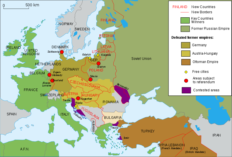
Size of this PNG preview of this SVG file: 800 × 543 pixels. Other resolutions: 320 × 217 pixels | 640 × 434 pixels | 1,024 × 695 pixels | 1,280 × 869 pixels | 2,560 × 1,738 pixels | 1,037 × 704 pixels.
Original file (SVG file, nominally 1,037 × 704 pixels, file size: 251 KB)
File history
Click on a date/time to view the file as it appeared at that time.
| Date/Time | Thumbnail | Dimensions | User | Comment | |
|---|---|---|---|---|---|
| current | 00:49, 30 July 2024 |  | 1,037 × 704 (251 KB) | Ratherous | Aland Islands |
| 10:43, 17 May 2024 |  | 1,037 × 704 (230 KB) | Andrei Stroe | File uploaded using svgtranslate tool (https://svgtranslate.toolforge.org/). Added translation for ro. | |
| 13:42, 11 November 2015 |  | 1,037 × 704 (188 KB) | Oosterhagen | The Netherlands as neutral | |
| 14:24, 15 August 2015 |  | 1,037 × 704 (177 KB) | Fluteflute | Correct misspelling. Sweeden -> Sweden | |
| 16:21, 13 January 2009 |  | 1,037 × 704 (187 KB) | Fluteflute | small text changes | |
| 16:17, 13 January 2009 |  | 1,037 × 704 (187 KB) | Fluteflute | {{Information |Description={{en|Map of Europe in 1923.}} {{fr|Carte de l'Europe en 1923.}} |Source=*File:Map_Europe_1923-fr.svg |Date=2009-01-13 16:16 (UTC) |Author=*derivative work: ~~~ *File:Map_Europe_1923-fr.svg: [[User:Historicair|Histori |
File usage
The following 25 pages use this file:
- 1917 Franco-Russian agreement
- 20th century
- Aftermath of World War I
- Balkanization
- Causes of World War II
- Flight and expulsion of Germans (1944–1950)
- History of U.S. foreign policy, 1913–1933
- History of Western civilization
- January 1920
- List of national border changes (1914–present)
- Molotov–Ribbentrop Pact
- Nation state
- Presidency of Warren G. Harding
- Presidency of Woodrow Wilson
- Revanchism
- Self-determination
- Territorial evolution of Russia
- Treaty of Versailles
- Woodrow Wilson
- World War I
- User:Falcaorib/Europe
- User:Sm8900/harding
- Wikipedia:Graphics Lab/Map workshop/Archive/2016
- Wikipedia:WikiProject Military history/News/June 2019/Op-ed
- Portal:Modern history
Global file usage
The following other wikis use this file:
- Usage on af.wikipedia.org
- Usage on ar.wikipedia.org
- Usage on azb.wikipedia.org
- Usage on az.wikipedia.org
- Usage on be-tarask.wikipedia.org
- Usage on bn.wikibooks.org
- Usage on ca.wikipedia.org
- Usage on ckb.wikipedia.org
- Usage on cy.wikipedia.org
- Usage on en.wikibooks.org
- Usage on eo.wikipedia.org
- Usage on eu.wikipedia.org
- Usage on fa.wikipedia.org
- Usage on fi.wikipedia.org
- Usage on fi.wikibooks.org
- Usage on ga.wikipedia.org
- Usage on hy.wikipedia.org
- Usage on hyw.wikipedia.org
- Usage on id.wikipedia.org
- Usage on it.wikipedia.org
- Usage on ja.wikipedia.org
- Usage on ka.wikipedia.org
- Usage on kbd.wikipedia.org
- Usage on ko.wikipedia.org
- Usage on lv.wikipedia.org
- Usage on no.wikipedia.org
- Usage on pa.wikipedia.org
- Usage on pl.wikipedia.org
- Usage on pnb.wikipedia.org
- Usage on pt.wikipedia.org
- Usage on ro.wikipedia.org
- Usage on sl.wikipedia.org
- Usage on sr.wikipedia.org
- Usage on sv.wikipedia.org
- Usage on te.wikipedia.org
View more global usage of this file.


