Size of this preview: 800 × 551 pixels. Other resolutions: 320 × 220 pixels | 640 × 441 pixels | 976 × 672 pixels.
Original file (976 × 672 pixels, file size: 204 KB, MIME type: image/jpeg)
File history
Click on a date/time to view the file as it appeared at that time.
| Date/Time | Thumbnail | Dimensions | User | Comment | |
|---|---|---|---|---|---|
| current | 14:05, 5 September 2013 |  | 976 × 672 (204 KB) | DancingPhilosopher | Adriatic Sea in blue colored hash |
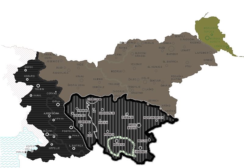
| 15:54, 1 February 2013 |  | 976 × 672 (183 KB) | DancingPhilosopher | Province of Ljubljana within the borders of present-day Slovenia, showing Slovene territory divided between Nazi Germany, Hungary, and Italy, including the area already annexed by Italy with the Treaty of Rapallo. | |
| 19:03, 21 October 2010 |  | 779 × 643 (71 KB) | DerBorg | little graphic fix | |
| 02:11, 16 September 2008 |  | 796 × 643 (71 KB) | Spalatino | {{Information |Description={{en|1=Map of the Italian "Provincia di Lubiana", that existed between 1941 and 1943. I have added in green the borders of the german ethnic community of Gotschee (that existed inside Slovenia until 1940).}} |Source=Own work by |
File usage
The following 8 pages use this file:
Global file usage
The following other wikis use this file:
- Usage on ar.wikipedia.org
- Usage on bs.wikipedia.org
- Usage on cs.wikipedia.org
- Usage on de.wikipedia.org
- Usage on es.wikipedia.org
- Usage on fr.wikipedia.org
- Usage on id.wikipedia.org
- Usage on it.wikipedia.org
- Usage on ja.wikipedia.org
- Usage on mk.wikipedia.org
- Usage on mt.wikipedia.org
- Usage on pl.wikipedia.org
- Usage on pt.wikipedia.org
- Usage on rue.wikipedia.org
- Usage on ru.wikipedia.org
- Usage on sh.wikipedia.org
- Usage on sl.wikipedia.org
- Usage on sr.wikipedia.org
- Usage on sv.wikipedia.org
- Usage on tr.wikipedia.org
- Usage on uk.wikipedia.org
- Usage on www.wikidata.org


