Redcliffe_Division,_March_1902.jpg (233 × 244 pixels, file size: 44 KB, MIME type: image/jpeg)
| This is a file from the Wikimedia Commons. Information from its description page there is shown below. Commons is a freely licensed media file repository. You can help. |
Summary
| DescriptionRedcliffe Division, March 1902.jpg |
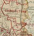
English: Map of Redcliffe Division and adjacent local government areas, March 1902. Legend: Kedron Division & Sandgate Borough (See Diagram) |
| Date | |
| Source | Queensland, illustrating Local Authorities Districts[1], Queensland. Survey Office, 1902, available on Commons as File:Queensland-Divisions-1902.jpg |
| Author | Queensland Survey Office |
| Camera location | 27° 13′ 32.52″ S, 153° 06′ 30.6″ E | View this and other nearby images on: OpenStreetMap |
|---|
Crop of File:Queensland-Divisions-1902.jpg to focus on Redcliffe Division. Legend information taken from lower right corner of original map.
Licensing
| Public domainPublic domainfalsefalse |
This image or other work is of Australian origin and is now in the public domain because its term of copyright has expired. According to the Australian Copyright Council (ACC), ACC Information Sheet G023v19 (Duration of copyright) (January 2019).1
When using this template, please provide information of where the image was first published and who created it. العربية ∙ català ∙ Deutsch ∙ English ∙ español ∙ français ∙ 日本語 ∙ македонски ∙ മലയാളം ∙ Nederlands ∙ русский ∙ slovenščina ∙ Tok Pisin ∙ Türkçe ∙ українська ∙ 简体中文 ∙ 繁體中文 ∙ +/− |
||||||||||||||||||||
Captions
Add a one-line explanation of what this file represents
Items portrayed in this file
depicts
30 October 2013
27°13'32.5"S, 153°6'30.6"E
File history
Click on a date/time to view the file as it appeared at that time.
| Date/Time | Thumbnail | Dimensions | User | Comment | |
|---|---|---|---|---|---|
| current | 03:40, 28 December 2013 |  | 233 × 244 (44 KB) | Kerry Raymond | User created page with UploadWizard |
File usage
The following page uses this file:
Metadata
This file contains additional information, probably added from the digital camera or scanner used to create or digitize it.
If the file has been modified from its original state, some details may not fully reflect the modified file.
| Camera manufacturer | NIKON CORPORATION |
|---|---|
| Camera model | NIKON D3X |
| Exposure time | 2/5 sec (0.4) |
| F-number | f/8 |
| ISO speed rating | 100 |
| Date and time of data generation | 11:53, 30 October 2013 |
| Lens focal length | 50 mm |
| Width | 4,159 px |
| Height | 6,000 px |
| Bits per component |
|
| Compression scheme | Uncompressed |
| Pixel composition | RGB |
| Orientation | Normal |
| Number of components | 3 |
| Horizontal resolution | 600 dpi |
| Vertical resolution | 600 dpi |
| Data arrangement | chunky format |
| Software used | Adobe Photoshop CS4 Macintosh |
| File change date and time | 14:14, 30 October 2013 |
| Exposure Program | Manual |
| Exif version | 2.21 |
| Date and time of digitizing | 11:53, 30 October 2013 |
| Shutter speed | 1.321928 |
| APEX aperture | 6 |
| Exposure bias | 0 |
| Maximum land aperture | 2 APEX (f/2) |
| Metering mode | Pattern |
| Light source | Unknown |
| Flash | Flash did not fire |
| DateTime subseconds | 74 |
| DateTimeOriginal subseconds | 74 |
| DateTimeDigitized subseconds | 74 |
| Color space | Uncalibrated |
| Sensing method | One-chip color area sensor |
| File source | Digital still camera |
| Scene type | A directly photographed image |
| Custom image processing | Normal process |
| Exposure mode | Manual exposure |
| White balance | Auto white balance |
| Digital zoom ratio | 1 |
| Focal length in 35 mm film | 50 mm |
| Scene capture type | Standard |
| Scene control | None |
| Contrast | Normal |
| Saturation | Normal |
| Sharpness | Normal |
| Subject distance range | Unknown |
| Serial number of camera | 5028105 |
| Lens used | Zeiss Makro-Planar T* 2/50 ZF.2 |
| Image width | 4,159 px |
| Image height | 6,000 px |
| Rating (out of 5) | 0 |
| Date metadata was last modified | 00:14, 31 October 2013 |
| Unique ID of original document | 0E1C7EFA9E45D46037F129ED3E524976 |

