Dřevíkov
Dřevíkov | |
|---|---|
Village | |
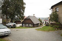
 Lower part of Dřevíkov | |
| Coordinates: 49°45′52″N 15°49′43″E / 49.76444°N 15.82861°E | |
| Country | |
| Region | Pardubice |
| District | Chrudim |
| Municipality | Vysočina |
| First mentioned | 1542 |
| Area | |
• Total | 1.68 km2 (0.65 sq mi) |
| Elevation | 569 m (1,867 ft) |
| Population (2021)[1] | |
• Total | 74 |
| • Density | 44/km2 (110/sq mi) |
| Time zone | UTC+1 (CET) |
| • Summer (DST) | UTC+2 (CEST) |
| Postal code | 539 01 |
Dřevíkov is a village and municipal part of Vysočina in Chrudim District in the Pardubice Region of the Czech Republic. It has about 70 inhabitants. It is located in the central part of the municipality.
Etymology
[edit]The name is derived from the personal name Dřevík, meaning "Dřevík's (court)".[2]
Geography
[edit]Dřevíkov is located in the central part of the Vysočina municipality, about 20 kilometres (12 mi) south of Chrudim and 30 km (19 mi) south of Pardubice. It lies in the Iron Mountains and in the eponymous protected landscape area.
History
[edit]The first written mention of Dřevíkov is from 1542.[2] Since 1961, it has been a part of Vysočina.[3]
The history of the village is connected with the Jewish community that lived here. The first Jewish settlers came to Dřevíkov in the first half of the 18th century. Between 1837 and 1849, there was at least 25 Jewish families in the village (almost half of Dřevíkov's total population). As the Jewish people gained all civil rights, they started leaving Dřevíkov. The last Jewish family left Dřevíkov in 1910.[4]
Demographics
[edit]
|
|
| ||||||||||||||||||||||||||||||||||||||||||||||||||||||
| Source: Censuses[5][6] | ||||||||||||||||||||||||||||||||||||||||||||||||||||||||
Transport
[edit]The I/37 road (the section from Chrudim to Žďár nad Sázavou) runs west of the village.
Sights
[edit]
A cultural monument is the former Jewish street, which was established after 1701, when several Jewish families moved here. The street is an example of local folk architecture.[7] Among the buildings in the street is the former synagogue, fro mthe second half of the 18th century.[4]
The Jewish community is commemorated by the Jewish cemetery. It was founded before 1740 and expanded to its current size in 1870. It is one of the best-preserved rural Jewish cemeteries in the Czech Republic, with a collection of valuable Baroque, Neoclassical and modern tombstones.[8]
References
[edit]- ^ "Výsledky sčítání 2021 – otevřená data" (in Czech). Czech Statistical Office. 2022-12-21.
- ^ a b Profous, Antonín (1947). Místní jména v Čechách I: A–H (in Czech). p. 467.
- ^ "Historický lexikon obcí České republiky 1869–2011: Abecední přehled obcí a částí obcí" (PDF) (in Czech). Czech Statistical Office. 2015-12-21. p. 111.
- ^ a b "Dřevíkov". Holocaust.cz (in Czech). Retrieved 2025-02-07.
- ^ "Historický lexikon obcí České republiky 1869–2011" (in Czech). Czech Statistical Office. 2015-12-21.
- ^ "Population Census 2021: Population by sex". Public Database. Czech Statistical Office. 2021-03-27.
- ^ "Soubor objektů židovská ulička" (in Czech). National Heritage Institute. Retrieved 2025-02-07.
- ^ "Židovský hřbitov" (in Czech). National Heritage Institute. Retrieved 2025-02-07.

