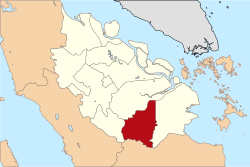
Indragiri Hulu (Upper Indragiri) is a landlocked regency (kabupaten) of Riau, Indonesia. It is located on the island of Sumatra. The original regency was split in two on 4 October 1999, with the western half being created as a separate Kuantan Singingi Regency. The regency now has an area of 8,198.71 km2 and had a population of 363,442 at the 2010 census,[2] 408,704 at the 2015 census and 444,548 at the 2020 census;[3] the official estimate as at mid 2023 was 472,799 (comprising 51.26% males and 48.74% females).[1] The administrative seat of the regency is located at the town of Rengat.
Upper Indragiri Regency
Kabupaten Indragiri Hulu | |
|---|---|
 Malay traditional house in Indragiri Hulu | |
 | |
| Country | Indonesia |
| Province | Riau |
| Regency seat | Rengat |
| Area | |
• Total | 8,198.21 km2 (3,165.35 sq mi) |
| Population (2023 estimate)[1] | |
• Total | 472,799 |
| • Density | 58/km2 (150/sq mi) |
| Time zone | UTC+7 (WIB) |
| Website | www.inhu.go.id |
Administrative districts
editThe regency is divided into fourteen districts (kecamatan), listed below with their areas and their populations at the 2010 census[2] and the 2020 census,[3] together with the official estimates as at mid 2023.[1] The table also includes the locations of the district administrative centres, the number of administrative villages in each district (totaling 178 rural desa and 16 urban kelurahan), and its post code.
| Kode Wilayag |
Name of District (kecamatan) |
Area in km2 |
Pop'n census 2010 |
Pop'n census 2020 |
Pop'n estimate mid 2023 |
Admin centre |
No. of villages |
Post code |
|---|---|---|---|---|---|---|---|---|
| 14.02.05 | Peranap | 1,700.98 | 28,231 | 35,161 | 37,940 | Peranap | 12 (a) | 29357 |
| 14.02.14 | Batang Peranap | (b) | 8,980 | 13,252 | 14,666 | Selunak | 10 | 29354 |
| 14.02.06 | Seberida | 960.29 | 46,155 | 56,571 | 59,672 | Pangkalan Kasai | 11 (c) | 29371 |
| 14.02.07 | Batang Cenaku | 970.00 | 28,393 | 40,736 | 48,053 | Aur Cina | 20 | 29355 |
| 14.02.08 | Batang Gansal | 950.00 | 26,890 | 33,272 | 35,146 | Seberida | 10 | 29356 |
| 14.02.03 | Kelayang | 879.84 | 21,288 | 24,542 | 26,258 | Simpang Kelayang | 17 (c) | 29352 |
| 14.02.13 | Rakit Kulim | (b) | 19,833 | 23,836 | 25,062 | Petonggan | 19 | 29359 |
| 14.02.04 | Pasir Penyu | 372.50 | 31,116 | 36,234 | 37,260 | Air Molek | 13 (d) | 29358 |
| 14.02.09 | Lirik | 233.60 | 23,418 | 27,624 | 28,203 | Lirik Area | 17 | 29353 |
| 14.02.11 | Sungai Lala | (b) | 12,938 | 16,608 | 17,863 | Kelawat | 12 | 29363 |
| 14.02.12 | Lubuk Batu Jaya | (b) | 18,560 | 22,981 | 23,545 | Lubuk Batu Tinggal | 9 | 29350 |
| 14.02.02 | Rengat Barat (West Rengat) |
921.00 | 39,819 | 48,573 | 51,516 | Permatang Reba | 18 (c) | 29351 (e) |
| 14.02.01 | Rengat | 1,210.50 | 46,049 | 50,603 | 52,285 | Rengat | 16 (f) | 29311 - 29319 |
| 14.02.10 | Kuala Cenaku | (b) | 11,772 | 14,555 | 15,330 | Kuala Cenaku | 10 | 29335 |
| Totals | 8,198.71 | 363,442 | 444,548 | 472,799 | Rengat | 194 |
Notes: (a) including 2 kelurahan - Baturijal Hilir and Peranap. (b) the area of this district is still included in the figures for the district from which it was cut out. (c) including one kelurahan - the admin centre.
(d) including 5 kelurahan - Air Molek I, Kembang Harum, Sekar Mawar, Tanah Merah and Tanjung Gading.
(e) except the village of Rantau Bakung, which has a post code of 29345.
(f) including 6 kelurahan - Kampung Besar Kota, Kampung Besar Seberang, Kampung Dagang, Pasar Kota, Sekip Hilir and Sekip Hulu.
References
edit0°21′00″S 102°31′59″E / 0.35000°S 102.53306°E
