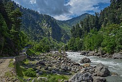
The Kunhar River[1] (Urdu: دریائے کنہار) or River Kunhar, is a 177 kilometres (110 mi) long river, located primarily in the Khyber Pakhtunkhwa province, northern Pakistan. It is in the Indus River watershed basin.[2]
| Kunhar | |
|---|---|
 Kunhar River, Khyber Pakhtunkhwa | |
 | |
| Native name | دریائے کنہار (Urdu) |
| Location | |
| Country | Pakistan |
| province | Khyber Pakhtunkhwa |
| District | Mansehra District |
| Physical characteristics | |
| Source | Lulusar lake |
| • elevation | 3,950 m (12,960 ft) |
| Mouth | Jhelum River |
• location | Muzaffarabad |
| Length | 177 km (110 mi) |

Origin and route
editKunhar is the main river in the Naran Valley.[3] It originates from the Lulusar Lake, near the Babusar Pass at the elevation of 3455m, in the Kaghan Valley.[2][3] Melting snow and natural tributaries are the main source of water for the Kunhar river.[3] It joins Jhelum river at Pattan.[2]
See also
editReferences
edit- ^ Fahim Zaman (29 Nov 2020). "Death of a River". Dawn.
- ^ a b c Abbasi, Arshad Mehmood; Shah, Munir Hussain; Khan, Mir Ajab (2014-10-15). Wild Edible Vegetables of Lesser Himalayas: Ethnobotanical and Nutraceutical Aspects, Volume 1. Springer. p. 13. ISBN 978-3-319-09543-1.
- ^ a b c Öztürk, Münir; Hakeem, Khalid Rehman; Faridah-Hanum, I.; Efe, Recep (2015-05-05). Climate Change Impacts on High-Altitude Ecosystems. Springer. pp. 156–163. ISBN 978-3-319-12859-7.
Sources
edit- Bundschuh, Jochen; A, Mario César Suárez (2010-07-05). Introduction to the Numerical Modeling of Groundwater and Geothermal Systems: Fundamentals of Mass, Energy and Solute Transport in Poroelastic Rocks. CRC Press. ISBN 978-0-415-40423-5.
External links
editWikimedia Commons has media related to Saiful Muluk Lake.
Wikimedia Commons has media related to Kunhar River.
34°17′N 73°29′E / 34.283°N 73.483°E