File:1937 Tree plan - St. Elizabeths Hospital West Campus, 2700 Martin Luther King Jr. Avenue, Southeast, Washington, District of Columbia, DC HALS DC-11 (sheet 3 of 7).tif

Original file (14,400 × 9,600 pixels, file size: 395.58 MB, MIME type: image/tiff)
| This is a file from the Wikimedia Commons. Information from its description page there is shown below. Commons is a freely licensed media file repository. You can help. |
| Warning | The original file is very high-resolution. It might not load properly or could cause your browser to freeze when opened at full size. |
|---|
Summary
| 1937 Tree plan - St. Elizabeths Hospital West Campus, 2700 Martin Luther King Jr. Avenue, Southeast, Washington, District of Columbia, DC | ||||
|---|---|---|---|---|
| Photographer |
Heritage Landscapes |
|||
| Title |
1937 Tree plan - St. Elizabeths Hospital West Campus, 2700 Martin Luther King Jr. Avenue, Southeast, Washington, District of Columbia, DC |
|||
| Depicted place | District of Columbia; District of Columbia; Washington | |||
| Date | 2009 | |||
| Dimensions | 24 x 36 in. (D size) | |||
| Current location |
Library of Congress Prints and Photographs Division Washington, D.C. 20540 USA http://hdl.loc.gov/loc.pnp/pp.print |
|||
| Accession number |
HALS DC-11 (sheet 3 of 7) |
|||
| Credit line |
|
|||
| Notes |
internationally significant historic resource that documents in physical form the evolution of medical treatment for mental health patients in the United States. Positioned on the bluffs overlooking the confluence of the Potomac and Anacostia Rivers, this approximately 176-acre property commands an impressive panorama. The site selection, site planning for the buildings, and development of the hospital grounds integrate the landscape with the medical treatment of patients. This was a remarkable innovation in this type of institution marking a shift away from incarceration treatment toward active therapeutic treatment of mental illness. The historic significance of St. Elizabeths Hospital is nationally recognized by incorporation on national and local historic district registers. The campus including the cultural landscape is listed on the National Register of Historic Places (NRHP). The campus was designated a National Historic Landmark (NHL) in 1991, and received District of Columbia Historic District Designation in May of 2005. The St. Elizabeths Hospital West Campus cultural landscape incorporates historic significance to varying degrees in all four National Register criteria. The cultural landscape of the hospital is associated with events that have made a significant contribution to the broad patterns of United States history. The historic campus remains a largely intact testament to the history of the social reform movement and the history of mental health care in the United States. The West Campus is also associated with the lives of persons significant in the past including social reformer Dorthea Lynde Dix, mental health advocate Dr. Charles H. Nichols and architect of the Capitol Thomas U. Walter. The origin of the first national mental health institution lies in the lobbying efforts of Dorthea Dix and in the planning and design of the initial grounds and buildings by first Superintendent Charles Nichols and Thomas Walter. Important asylum planners including psychiatrist Dr. Thomas S. Kirkbride and landscape architect Andrew J. Downing inspired Dr. Charles Nichols and Thomas Walter. In addition, the southern expansion of the West Campus under Superintendent Alonzo Richardson was carried out by architects Shepley Rutan and Coolidge and influenced by renowned landscape architect Frederick Law Olmsted, Jr. and the Olmsted Brothers. The cultural landscape of the hospital continues to embody the distinctive characteristics of a type and period of construction. The West Campus exists as one of the few surviving nineteenth-century hospitals where the therapeutic use of the grounds was designed as an essential component of the health and healing of patients. The St. Elizabeths Hospital landscape bears evidence of the evolution of hospital design from its origin in the 1850s to its complete development in the early 1940s.
|
|||
| References |
Related names:
|
|||
| Source | https://www.loc.gov/pictures/item/dc1042.sheet.00003a | |||
| Permission (Reusing this file) |
|
|||
| Other versions |
.png) |
|||

| Object location | | View this and other nearby images on: OpenStreetMap |
|---|
File history
Click on a date/time to view the file as it appeared at that time.
| Date/Time | Thumbnail | Dimensions | User | Comment | |
|---|---|---|---|---|---|
| current | 00:58, 10 July 2014 | 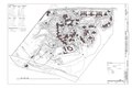 | 14,400 × 9,600 (395.58 MB) | Fæ | GWToolset: Creating mediafile for Fæ. HABS 09 July 2014 (801:1000) |
File usage
The following page uses this file: