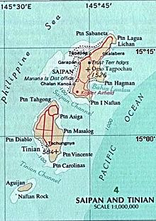
San Jose is the largest village on the island of Tinian, in the Northern Mariana Islands. It is located on the south coast of the island, close to the island's main harbor and three beaches: Kammer Beach, Taga Beach, and Tachogña Beach (Tachungnya).[1][2]


Now home to most of Tinian's population of about 3,136 (2010), San Jose is close to the site of a much larger ancient village of the Chamorro culture, which may have housed 12,000–15,000 people.
The main roads in San Jose are 8th Ave and Broadway. Just north of the City of San Jose is the neighborhood Marpo Heights. Carolinas Heights neighborhood is just east of the city of San Jose. Tachogña Beach (Tachungnya) is just south of the city. Tinian International Airport is 4.2 km north of San Jose. Kammer Beach is in the City of San Jose, next to the harbor. Taga Beach is south of the city, next to Tachogña Beach.
During World War II the US Navy Seabees built, as part of the Tinian Naval Base, Tinian Harbor, also called San Jose Harbor, which is still in use today. They also constructed Broadway and 8th Avenue, named after Broadway and 8th Avenue in Manhattan. US Navy and US Army often called San Jose Tinian Town. Most of the city of San Jose was destroyed in the battle of Tinian and then rebuilt.[3][4]
References
edit- ^ "Physical development master plan for the Commonwealth of the Northern Mariana Islands". www.govinfo.gov. Retrieved 2023-01-18.
- ^ "USGS 145808145372470 San Jose Rain Can, Tinian, CNMI". nwis.waterdata.usgs.gov. Retrieved 2023-01-18.
- ^ Prefer, Nathan N. The Battle for Tinian: Vital Stepping Stone in America's War Against Japan. Havertown, Pa.: Casemate Publishers, 2012. ISBN 978-1-61200-107-4. pp. 155–156.
- ^ "Building the Navy's Bases, vol. 2 (part III, chapter 26)". NHHC. Retrieved 2023-01-18.
14°58′16″N 145°37′33″E / 14.9711°N 145.6259°E