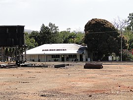
Almaden is a rural town and locality in the Shire of Mareeba, Queensland, Australia.[2][3] In the 2021 census, the locality of Almaden had a population of 41 people.[1]
| Almaden Queensland | |||||||||||||||
|---|---|---|---|---|---|---|---|---|---|---|---|---|---|---|---|
 Railway Hotel at Almaden | |||||||||||||||
| Coordinates | 17°20′26″S 144°40′37″E / 17.3406°S 144.6769°E | ||||||||||||||
| Population | 41 (2021 census)[1] | ||||||||||||||
| • Density | 0.0514/km2 (0.1331/sq mi) | ||||||||||||||
| Postcode(s) | 4871 | ||||||||||||||
| Area | 797.6 km2 (308.0 sq mi) | ||||||||||||||
| Time zone | AEST (UTC+10:00) | ||||||||||||||
| Location | |||||||||||||||
| LGA(s) | Shire of Mareeba | ||||||||||||||
| State electorate(s) | |||||||||||||||
| Federal division(s) | Kennedy | ||||||||||||||
| |||||||||||||||
Geography
editAlmaden is on the Mareeba-to-Chillagoe railway line (part of the Tablelands railway line) which runs between Mareeba and the mining and cattle town of Mungana. Almaden railway station serves the town (17°20′18″S 144°40′41″E / 17.3384°S 144.6780°E).[4] The Etheridge railway line branches off at Almdaden towards Forsayth, with Ootann railway station, in the south of the locality of Almaden (17°25′59″S 144°38′19″E / 17.4331°S 144.6385°E).[4]
The Burke Developmental Road passes through from east to north-west. Ootann Road exits to the south. [5]
History
editThe town is named after the town of Almadén in Cuidad Real Province, Spain, which is known for its mercury mine. The mineral deposits in Queensland's Almaden are tripolite (diatomite).[3]
Tate Tin Mines Provisional School opened on 17 October 1894. On 1 January 1909 it became Tate Tin Mines State School. It closed on 31 Jan 1924 but reopened on 3 February 1930. It closed permanently on 31 December 1940.[6]
Almaden Provisional School opened on 6 July 1906 on a 5-acre (2.0 ha) site.[7][8][9] On 1 January 1909 it became Almaden State School. It closed on 12 December 1997.[6][10] It was at 22 Almaden Second Street (17°20′32″S 144°40′44″E / 17.3421°S 144.6789°E). It is now a tourist park.[11][12]
Ootann Provisional School opened on 23 May 1929 and closed circa 1933.[6]
Demographics
editIn the 2016 census, the locality of Almaden had a population of 71 people.[13]
In the 2021 census, the locality of Almaden had a population of 41 people.[1]
Education
editThere are no schools in Almaden. The nearest government primary school is Chillagoe State School in neighbouring Chillagoe to the north-west. The nearest secondary school is Dimbulah State School (to Year 10) in Dimbulah to the north-west. For secondary education to Year 12, the options are distance education and boarding schools.[14]
Attractions
editThe town is an overnight stop for the Savannahlander which operates twice weekly between Cairns and Forsayth.[15]
References
edit- ^ a b c Australian Bureau of Statistics (28 June 2022). "Almaden (SAL)". 2021 Census QuickStats. Retrieved 28 February 2023.
- ^ "Almaden – town in Shire of Mareeba (entry 447)". Queensland Place Names. Queensland Government. Retrieved 28 December 2020.
- ^ a b "Almaden – locality in Shire of Mareeba (entry 48494)". Queensland Place Names. Queensland Government. Retrieved 28 December 2020.
- ^ a b "Railway stations and sidings - Queensland". Queensland Open Data. Queensland Government. 2 October 2020. Archived from the original on 5 October 2020. Retrieved 5 October 2020.
- ^ Almaden, Queensland (Map). OpenStreetMap. Archived from the original on 17 April 2022. Retrieved 13 April 2022.
- ^ a b c Queensland Family History Society (2010), Queensland schools past and present (Version 1.01 ed.), Queensland Family History Society, ISBN 978-1-921171-26-0
- ^ "TELEGRAMS". Morning Post (Cairns). Vol. 19, no. 330. Queensland, Australia. 19 January 1906. p. 2. Archived from the original on 30 April 2022. Retrieved 30 April 2022 – via National Library of Australia.
- ^ "CHILLAGOE NOTES". Morning Post (Cairns). Vol. 19, no. 347. Queensland, Australia. 8 February 1906. p. 4. Archived from the original on 30 April 2022. Retrieved 30 April 2022 – via National Library of Australia.
- ^ "RURAL INTERESTS". The Brisbane Courier. Vol. LXII, no. 15, 103. Queensland, Australia. 8 June 1906. p. 2. Archived from the original on 30 April 2022. Retrieved 30 April 2022 – via National Library of Australia.
- ^ "Queensland state school - centre closures" (PDF). Queensland Government. 20 August 2013. Archived (PDF) from the original on 20 March 2022. Retrieved 7 April 2022.
- ^ "Accommodation Feature – Tamarind Gardens, Almaden". Archived from the original on 6 March 2021. Retrieved 30 April 2022.
- ^ "22 Almaden Street, Almaden QLD 4871". Allhomes. Archived from the original on 30 April 2022. Retrieved 30 April 2022.
- ^ Australian Bureau of Statistics (27 June 2017). "Almaden (SSC)". 2016 Census QuickStats. Retrieved 20 October 2018.
- ^ "Queensland Globe". State of Queensland. Retrieved 26 March 2021.
- ^ "Savannahlander Itinerary". Archived from the original on 13 November 2019. Retrieved 13 November 2019.
External links
editMedia related to Almaden, Queensland at Wikimedia Commons
