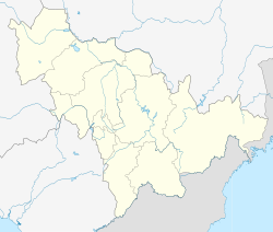
Linjiang (simplified Chinese: 临江; traditional Chinese: 臨江; pinyin: Línjiāng; listed as Linkiang on old maps) is a county-level city in Baishan, Jilin, China. It is located to the east of Tonghua, and borders North Korea along the Yalu River.
Linjiang
临江市 | |
|---|---|
 Location in Baishan City | |
| Coordinates: 41°49′N 126°55′E / 41.817°N 126.917°E | |
| Country | People's Republic of China |
| Province | Jilin |
| Prefecture-level city | Baishan |
| Township-level divisions | 6 subdistricts 6 towns 1 township |
| Municipal seat | Jianguo Subdistrict (建国街道) |
| Area | |
| 3,009 km2 (1,162 sq mi) | |
| • Urban | 170.84 km2 (65.96 sq mi) |
| Elevation | 341 m (1,119 ft) |
| Population (2017)[1] | |
| 162,000 | |
| • Density | 54/km2 (140/sq mi) |
| • Urban | 97,100 |
| Time zone | UTC+8 (China Standard) |
| Postal code | 134600 |
Culture
editDuring 1953–76, there was a total of twenty one Chinese films being shot on location in Linjiang, including Visitors on the Icy Mountain.[2]
Geography and climate
editLinjiang has a monsoon-influenced humid continental climate (Köppen Dwa), with long, very cold winters, and very warm, humid summers. Monthly average temperatures range from −15.3 °C (4.5 °F) in January to 22.3 °C (72.1 °F) in July, and the annual mean is 5.57 °C (42.0 °F). Though the annual total is generous, precipitation is quite low during the winter and rainfall is concentrated in the months of June through August. Sunshine is generous but falling far short of the central and western parts of Jilin; with monthly percent possible sunshine ranging from 42% in July to 60% in February, there are 2,232 hours of bright sunshine annually.
| Climate data for Linjiang, elevation 380 m (1,250 ft), (1991–2020 normals) | |||||||||||||
|---|---|---|---|---|---|---|---|---|---|---|---|---|---|
| Month | Jan | Feb | Mar | Apr | May | Jun | Jul | Aug | Sep | Oct | Nov | Dec | Year |
| Record high °C (°F) | 4.7 (40.5) |
13.0 (55.4) |
18.8 (65.8) |
29.9 (85.8) |
33.4 (92.1) |
37.2 (99.0) |
37.9 (100.2) |
35.8 (96.4) |
30.6 (87.1) |
27.8 (82.0) |
18.4 (65.1) |
9.5 (49.1) |
37.9 (100.2) |
| Mean daily maximum °C (°F) | −7.8 (18.0) |
−1.9 (28.6) |
5.8 (42.4) |
15.3 (59.5) |
22.1 (71.8) |
26.1 (79.0) |
28.6 (83.5) |
27.6 (81.7) |
22.6 (72.7) |
15.0 (59.0) |
3.6 (38.5) |
−6.0 (21.2) |
12.6 (54.7) |
| Daily mean °C (°F) | −14.8 (5.4) |
−9.5 (14.9) |
−1.0 (30.2) |
7.8 (46.0) |
14.4 (57.9) |
19.2 (66.6) |
22.6 (72.7) |
21.5 (70.7) |
15.0 (59.0) |
7.1 (44.8) |
−2.3 (27.9) |
−12.0 (10.4) |
5.7 (42.2) |
| Mean daily minimum °C (°F) | −20.3 (−4.5) |
−15.7 (3.7) |
−6.7 (19.9) |
1.2 (34.2) |
7.8 (46.0) |
13.9 (57.0) |
18.4 (65.1) |
17.5 (63.5) |
10.1 (50.2) |
1.3 (34.3) |
−6.9 (19.6) |
−16.8 (1.8) |
0.3 (32.6) |
| Record low °C (°F) | −33.5 (−28.3) |
−29.4 (−20.9) |
−21.7 (−7.1) |
−10.6 (12.9) |
−1.9 (28.6) |
4.3 (39.7) |
8.5 (47.3) |
5.3 (41.5) |
−2.3 (27.9) |
−11.3 (11.7) |
−24.5 (−12.1) |
−29.5 (−21.1) |
−33.5 (−28.3) |
| Average precipitation mm (inches) | 10.0 (0.39) |
14.3 (0.56) |
23.7 (0.93) |
39.3 (1.55) |
84.3 (3.32) |
111.1 (4.37) |
196.2 (7.72) |
161.5 (6.36) |
67.0 (2.64) |
43.1 (1.70) |
37.4 (1.47) |
18.0 (0.71) |
805.9 (31.72) |
| Average precipitation days (≥ 0.1 mm) | 7.3 | 7.2 | 8.6 | 10.2 | 13.8 | 15.0 | 16.3 | 14.9 | 9.6 | 9.7 | 10.2 | 9.4 | 132.2 |
| Average snowy days | 10.4 | 9.3 | 9.5 | 3.5 | 0 | 0 | 0 | 0 | 0 | 1.8 | 9.3 | 12.0 | 55.8 |
| Average relative humidity (%) | 69 | 64 | 59 | 56 | 63 | 73 | 79 | 81 | 78 | 68 | 71 | 72 | 69 |
| Mean monthly sunshine hours | 165.9 | 175.9 | 205.7 | 200.3 | 216.6 | 198.9 | 191.5 | 187.2 | 179.5 | 188.0 | 142.4 | 141.6 | 2,193.5 |
| Percent possible sunshine | 56 | 58 | 55 | 50 | 48 | 44 | 42 | 44 | 48 | 55 | 49 | 50 | 50 |
| Source: China Meteorological Administration[3][4][5] | |||||||||||||
Administrative divisions
editThere are six subdistricts, six towns and one townships under the city's administration:[6]
Subdistricts
- Jianguo Subdistrict (建国街道), Xinshi Subdistrict (新市街道), Xinglong Subdistrict (兴隆街道), Dahu Subdistrict (大湖街道), Sengong Subdistrict (森工街道), Dalizi Subdistrict (大栗子街道)
Towns:
The only township is Mayihe Township (蚂蚁河乡)
See also
editReferences
edit- ^ a b Ministry of Housing and Urban-Rural Development, ed. (2019). China Urban Construction Statistical Yearbook 2017. Beijing: China Statistics Press. p. 50. Retrieved 11 January 2020.
- ^ Jin, Changguo (2014). "临江——一座小城21部老电影". Chinese National Geography (in Chinese) (8): 172–189.
- ^ 中国气象数据网 – WeatherBk Data (in Simplified Chinese). China Meteorological Administration. Retrieved 7 July 2023.
- ^ 中国气象数据网 (in Simplified Chinese). China Meteorological Administration. Retrieved 7 July 2023.
- ^ 中国地面国际交换站气候标准值月值数据集(1971-2000年). China Meteorological Administration. Archived from the original on 2013-09-21. Retrieved 2010-05-25.
- ^ 2011年统计用区划代码和城乡划分代码:临江市 (in Chinese). National Bureau of Statistics of the People's Republic of China. Retrieved 2013-02-19.
External links
edit
