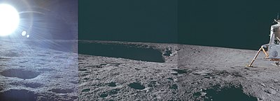
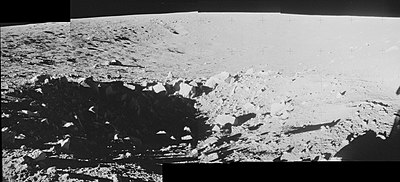
Surveyor crater is a small crater in Oceanus Procellarum on the Moon. The name of the crater was formally adopted by the IAU in 1973.[1]
 LRO Narrow Angle Camera image. The Apollo 12 Lunar Module Intrepid is in upper left, the Surveyor 3 lander is on the right side of the crater, and astronaut tracks are visible as dark lines. | |
| Coordinates | 3°01′S 23°25′W / 3.02°S 23.42°W |
|---|---|
| Diameter | 200 m[1] |
| Depth | 12 m[2] |
| Eponym | Astronaut-named feature |
On April 20, 1967, the Surveyor 3 spacecraft landed within the crater near the east rim. Surveyor 3 was the third lander of the American uncrewed Surveyor program sent to explore the surface of the Moon.
The Apollo 12 astronauts Pete Conrad and Alan Bean landed the Lunar Module (LM) Intrepid north of Surveyor crater on November 19, 1969, and eventually walked over to Surveyor 3. During their descent, Surveyor crater was a major landmark, and is the largest crater at the landing site. To the west of Surveyor is Head crater. To the southwest are Bench crater and Sharp crater (now called Sharp-Apollo). To the south is Halo crater. A distinct crater on the northeast rim is called Block crater.


Samples
editMany samples were collected in and around Surveyor crater.[3] Samples taken near the LM on the north rim of Surveyor crater include drive tube sample 12026,[4] and contingency samples 12073 (regolith breccia)[5] and 12075 (olivine basalt).[6] Soil Sample 12042 was collected on the southwest rim near Halo crater.[7] Samples 12043 (pigeonite basalt),[8] 12044 (soil),[9] 12051 (ilmenite basalt),[10] and 12054 (glass-coated ilmenite basalt)[11] were collected on the south rim. Samples 12056,[12] 12062,[13] 12063,[14] 12064[15] (all ilmenite basalts), and 12065 (pigeonite basalt)[16] were all likely collected in the interior of the crater near the east rim and northeast of the Surveyor 3 lander. Samples 12045,[17] 12046,[18] and 12047[19] (all ilmenite basalts) were collected at Block crater on the north rim of Surveyor crater.
-
Contingency samples 12073 and 12075 are in lower left
-
Drive tube sample 12026 in the lunar soil
-
Samples 12043 and 12044
-
Sample 12051 is in front of Commander Pete Conrad, below the gnomon
-
Sample 12054 near the gnomon
External links
edit- Lunar Orbiter 3 image 154 H2, used for planning the mission (landing site is left of center).
- Lunar Orbiter 1 sequence of images 157, 158, and 159, showing the Apollo 12 landing site and vicinity
References
edit- ^ a b Surveyor, Gazetteer of Planetary Nomenclature, International Astronomical Union (IAU) Working Group for Planetary System Nomenclature (WGPSN)
- ^ Surveyor Crater Map
- ^ Apollo 12 Preliminary Science Report, NASA Special Publication 235, 1970. Figure 10-1 (Traverse Map).
- ^ Sample 12026
- ^ Sample 12073
- ^ Sample 12075
- ^ Sample 12042
- ^ Sample 12043
- ^ Sample 12044
- ^ Sample 12051
- ^ Sample 12054
- ^ Sample 12056
- ^ Sample 12062
- ^ Sample 12063
- ^ Sample 12064
- ^ Sample 12065
- ^ Sample 12045
- ^ Sample 12046
- ^ Sample 12047