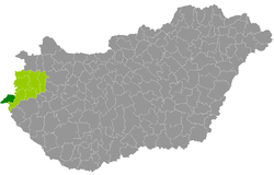
Szentgotthárd (Hungarian: Szentgotthárdi járás; Slovene: Monošter okrožje) is a district in south-western part of Vas County. Szentgotthárd is also the name of the town where the district seat is found. The district is located in the Western Transdanubia Statistical Region.
Szentgotthárd District
Szentgotthárdi járás | |
|---|---|
 Szentgotthárd District within Hungary and Vas County. | |
| Coordinates: 46°57′N 16°17′E / 46.95°N 16.28°E | |
| Country | |
| Region | Western Transdanubia |
| County | Vas |
| District seat | Szentgotthárd |
| Area | |
• Total | 255.04 km2 (98.47 sq mi) |
| • Rank | 7th in Vas |
| Population (2011 census) | |
• Total | 14,961 |
| • Rank | 6th in Vas |
| • Density | 59/km2 (150/sq mi) |
Geography
editThe Szentgotthárd District borders the Austrian state of Burgenland to the north and west, the Körmend District to the east, and Slovenia to the south.
Municipalities
editThe district consists of 16 municipalities, 1 town and 15 villages. The seat of the district is highlighted in bold:
| Municipality | Coat of arms | German name | Slovene name | Type | Area km2 |
Population[1] 2011 census |
|---|---|---|---|---|---|---|
| Alsószölnök | Unterzemming | Dolnji Senik | Village | 10.02 | 244 | |
| Apátistvánfalva | Stephansdorf | Števanovci | Village | 12.86 | 379 | |
| Csörötnek | Schriedling | Čretnik | Village | 20.53 | 947 | |
| Felsőszölnök | Oberzemming | Gornji Senik | Village | 23.56 | 592 | |
| Gasztony | Gasting | - | Village | 34.13 | 443 | |
| Kétvölgy | Permisch und Riegersdorf | Verica-Ritkarovci | Village | 6.28 | 110 | |
| Kondorfa | Kradendorf | Kradanovci | Village | 21.61 | 526 | |
| Magyarlak | Ungarisch-Minihof | Lak | Village | 7.62 | 777 | |
| Nemesmedves | Ginisdorf | - | Village | 4.74 | 19 | |
| Orfalu | Andelsdorf | Andovci | Village | 6.94 | 68 | |
| Rábagyarmat | Rupprecht | Žormot | Village | 16.79 | 822 | |
| Rátót | Neustift an der Raab | - | Village | 7.27 | 244 | |
| Rönök | Radling | Renik | Village | 10.02 | 424 | |
| Szakonyfalu | Eckersdorf | Sakalovci | Village | 11.19 | 364 | |
| Szentgotthárd | Sankt Gotthard | Monošter | Town | 67.73 | 8,629 | |
| Vasszentmihály | Sankt Michael an der Raab | - | Village | 6.41 | 345 |
Demographics
editReligion in Szentgotthárd District (2011 census)
In 2011, it had a population of 14,961 and the population density was 59/km².
| Year | County population[2] | Change |
|---|---|---|
| 2011 | 14,961 | n/a |
Ethnicity
editBesides the Hungarian majority, the main minorities are the Slovene (approx. 1,700), German (650) and Roma (350).
Total population (2011 census): 14,961
Ethnic groups (2011 census):[3] Identified themselves: 15,706 persons:
- Hungarians: 12,956 (82.49%)
- Slovenes: 1,656 (10.54%)
- Germans: 652 (4.15%)
- Gypsies: 331 (2.11%)
- Others and indefinable: 111 (0.71%)
Approx. 1,000 persons in Szentgotthárd District did declare more than one ethnic group at the 2011 census.
Religion
editReligious adherence in the county according to 2011 census:[4]
- Catholic – 10,487 (Roman Catholic – 10,474; Greek Catholic – 13);
- Reformed – 380;
- Evangelical – 202;
- Orthodox – 13;
- other religions – 77;
- Non-religious – 621;
- Atheism – 87;
- Undeclared – 3,094.
See also
editReferences
edit- ^ https://www.ksh.hu/nepszamlalas/docs/tables/regional/18/18_4_1_1_1_en.xls
- ^ népesség.com, "Szentgotthárdi járás népessége"
- ^ 4.1.6.1 A népesség nemzetiség szerint, 2011, (in Hungarian) [1]
- ^ 4.1.7.1 A népesség vallás, felekezet szerint, 2011, (in Hungarian) [2]
External links
edit
