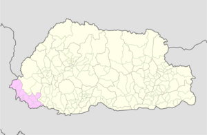
Tashicholing[a] (Dzongkha: བཀྲིས་ཙོས་གླིང་, romanized: bkris tsos gling) or Sipsu Gewog[1][2][b] is a gewog (village block) of the Samtse District, Bhutan.[3]
Tashicholing Gewog
བཀྲིས་ཙོས་གླིང་ Sipsu Gewog | |
|---|---|
| Coordinates: 27°00′27″N 88°52′48″E / 27.0074°N 88.8799°E | |
| Country | |
| District | Samtse District |
| Area | |
• Total | 27.67 km2 (10.68 sq mi) |
| Population (2012) | |
• Total | 4,087 |
| • Density | 150/km2 (380/sq mi) |
| Time zone | UTC+6 (BTT) |
Geography
editThe gewog is to the south of Pemaling gewog and southwest of Namgaychhoeling gewog. It is bordered by India's West Bengal state in the west and the south (Kalimpong and Jalpaiguri districts). The Dichu (or Jaldhaka) River forms the western border of the gewog, and the rivers Sipsu Jhora and Sati Khola flow through it before joining Dichu at the southwestern corner.
The Tashichholing Gewog occupies an area of 27.67 square kilometres (10.68 sq mi). It has 11 villages in 4 chiwogs.[2] In 2012, it had a population of 4,087.[4]
History
editThe village of Sipsu (also spelt Sibsu, Sibsoo and Sipchoo) had some encounters in history, as it appears to have been the seat of administration of the surrounding Dichu basin. In the 19th century, it was governed by deputy Dzongpön, perhaps under the control of a main Dzongpön at Dalingkot to the west.[5] The official spent the winter months at Sipsu and the summer months at Dzongsa Dzong,[c] which was six miles to the north.[6] Sipsu was bordered in the east by Sangbay, which also had a Dzongpön. The two districts were separated by the Tulela ridge.[7]
In 1863, the Eden Mission of British India, sent to negotiate an agreement with Bhutan regarding border relations, passed through Sipsu. The Bhutanese were reluctant to receive Eden and placed obstacles in his path. The porters hired by Eden in Darjeeling came as far as Sipsu, where they deserted him for fear of the Bhutanese.[8] Eden was given the impression that he would be able to obtain new porters at Sipsu, but the village was too small to offer any.[9] The Deputy Dzongpön of Sipsu told Eden that he had no orders to allow him entry into Bhutan, and could offer no assistance. Undeterred, Eden left most of his entourage and supplies at Sipsu, and proceeded with a smaller contingent via Tule La and Sangbay, towards Ha.[5] The Mission eventually reached the Bhutanese capital Punakha, but it was not successful, and led to further frictions and the Anglo-Bhutan War of 1864.
The war did not see any action at Sipsu, but Dalingkot faced an attack by British troops, and quickly fell, while there was a serious battle at Samtse.[10] At the end of the war, the Treaty of Sinchula (1865) was signed, in which unspecified "hill territory" of Dalingkot was ceded to the British as were all the duars to the south in return for an annual payment.[11] In 1866–1867 an Anglo-Bhutanese commission demarcated the borders, and set the Dichu and Nichu[d] rivers as the boundary of the Dalingkot area, making Sipsu a border district of Bhutan.[12][13]
Notes
edit- ^ Alternative spellings: Tashichholing and Tashichhoeling.
- ^ Alternative spellings: Sibsu, Sibsoo and Sibchoo.
- ^ Alternative spellings: Jongtsa, Jonksa, Dzongsar and Jumsatar. It is currently in the Dawathang_Kuengaling chiwog in the Tendu Gewog.
- ^ Nichu is a tributary of Dichu, flowing east from the Sikkim–Bhutan border ridge. It joins Dichu near Dzongsa, where also Bindu Khola joins it from the east.
References
edit- ^ Tashichholing Gewog, Samtse Dzongkhag Administration, archived from the original on 12 March 2018
- ^ a b Tashichholing Gewog, Samtse Dzongkhag Administration, retrieved 2 August 2022
- ^ "Chiwogs in Samtse" (PDF). Election Commission, Government of Bhutan. 2011. pp. 21–22. Archived from the original (PDF) on 2011-10-02.
- ^ Eleventh Five-Year Plan, Samtse Dzongkhag (PDF), Gross National Happiness Commission, Royal Government of Bhutan, 2013, Sec. 2 (Dzongkhag at a glance, 2012), ISBN 978-99936-55-01-5
- ^ a b Rennie, Bhotan and the Dooar War (1866), pp. 74–75.
- ^ Eden, Ashley (1864), Report on the State of Bootan and on the Progress of the Mission of 1863–1864, Government of India, p. 67 – via archive.org
- ^ Rennie, Bhotan and the Dooar War (1866), pp. 76–78.
- ^ Phuntsho, The History of Bhutan (2013), "The mission took the route to Haa via Sibsoo, where coolies again deserted them and Eden had to reduce his escort to fifteen men. The main reason for desertion, Eden says, was the fear of the Bhutanese, whom 'they looked upon as a race of murderers and robbers'.".
- ^ Rennie, Bhotan and the Dooar War (1866), pp. 73–74.
- ^ Rennie, Bhotan and the Dooar War (1866), pp. 178–179. Samtse is spelt "Sumchee" and it is clubbed with "Chamoorchee" (Chamurchi).
- ^ "History of Kalimpong". Darjeeling News Service. Archived from the original on 5 February 2007. Retrieved 17 February 2007.
- ^ Samanta, Amiya K. (2000). Gorkhaland Movement: A Study in Ethnic Separatism. APH Publishing. p. 43. ISBN 978-81-7648-166-3.
- ^ Hunter, W. W. (1876), A Statistical Account Of Bengal, Vol. X: Districts of Darjiling and Jalpaiguri, State of Kuch Behar, London: Trubner & Co, p. 19 – via archive.org: "In August 1866, by a Government Resolution, the hilly tract situated east of the Tista, west of the Ne-chu and De-chu rivers, and south of Independent Sikkim, being part of the territory acquired as the result of the Bhutan campaign of 1864, was added to the jurisdiction of Darjiling, and now forms the tract known as Damsang or Dalingkot."
Bibliography
edit- Phuntsho, Karma (2013), The History of Bhutan, Random House India, pp. 405–, ISBN 978-81-8400-411-3
- Rennie, Surgeon (1866), Bhotan and the Dooar War, John Murray – via archive.org
External links
edit- Tashichoeling Gewog, OpenStreetMap, retrieved 2 August 2022.
