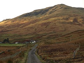
Tullich Hill (632 m) is a hill in the southern Grampian Mountains of Scotland. It lies south of the village of Arrochar, between Loch Long and Loch Lomond in Argyll.
| Tullich Hill | |
|---|---|
 Tullich Hill from Glen Douglas | |
| Highest point | |
| Elevation | 632 m (2,073 ft)[1] |
| Prominence | 273 m (896 ft) |
| Listing | Graham, Marilyn |
| Coordinates | 56°10′04″N 4°45′00″W / 56.1678°N 4.7499°W |
| Geography | |
 | |
| Location | Argyll and Bute, Scotland |
| Parent range | Grampian Mountains |
| OS grid | NN293006 |
| Topo map | OS Landranger 56 |
An irregular, rocky hill, its most distinguished feature is the corrie on its southern slopes.[2]
References
edit- ^ "Tullich Hill". hill-bagging.co.uk. Retrieved 23 October 2019.
- ^ "walkhighlands Tullich Hill". walkhighlands.co.uk. Retrieved 23 October 2019.